Various Information Used for Planning Wapta Icefields Ski Trip
March 13-20, 2008
Planning document used in preparation for trip - thanks to Robin for all the background work
Introduction,
Hazards,
Difficulties, Preparation
From the ACC description:
“This world-class winter ski-mountaineering destination is a
spectacular journey across the Wapta and Waputik Icefields, providing
you with fantastic views, amazing glacier runs, and the ultimate
backcountry experience.
Starting the traverse at Peyto Lake, we’ll make our way across the two
icefields, spending the evenings warming up, eating great food and
sleeping in the comforts of the Alpine Club of Canada’s Peyto, Bow,
Balfour and Scott Duncan Huts. Along the way many exciting
ski ascents are immediately adjacent to the traverse to try your hand
at ski mountaineering. Objectives could include Mounts
Rhondda (North and South), St. Nicholas, Olive, Gordon, and Balfour.”
As mentioned above the Wapta Traverse is an extended alpine tour across
some major icefields. This is probably the longest unguided tour of
glaciated terrain that our group members have done to date.
Generally the avalanche risk in the Canadian Rockies is the highest of
the major common ski areas in North America. Cold temperatures and
relatively shallow snow depths can produce high temperature gradients
and therefore unstable snow. Fortunately doing the trip in late March
bodes well for higher snow depths and moderating temperatures, although
any conditions are possible. There have been some persistent weak
layers in the Rockies this year, please see the article listed below.
Higher avalanche conditions would probably require sticking to safer
terrain vs. not being able to travel at all. This season has been
particularly bad for avalanches in Western Canada, although there is
nothing to indicate that we can’t do this trip safely at this point.
We can do a lot of research in advance to identify avalanche risk
areas. Please work on the following avalanche avoidance skills prior to
the trip if you have the chance: terrain analysis, safe group travel
practices, snow stability tests. I’ve been working on snow stability
test practice this winter. Please also monitor the avy bulletins for
the area- Tom will be archiving them on his website, pls see the link
below.
Rescue skills include group management and organization, transceiver
search for multiple victims, pinpoint searching and probing, shoveling.
Doing fast, efficient rescues is critical and requires practice, please
make the time to practice.
There are sections of the route in the vicinity of open crevasses (in
midwinter conditions) and icefalls. We’ll be taking rope and gear for
glacial travel and will probably have to ski roped up through some
difficult sections. We’ll plan on reviewing crevasse rescue as a group
early on during the traverse. We’ll have ropes and gear to handle a
full crevasse rescue scenario. In the event a full anchor has to be
built for hauling we will be using skis. We will be probing the snow
depth in suspect areas and in situations where we pull the group
together in one area, e.g. for a break.
We could have true winter conditions including whiteout, high winds,
heavy snowfall, and cold temperatures. Good navigation skills and gear
will be critical. We’ll have 2 GPS along on the trip and will be
preparing in advance with coordinates and maps. We’ll also be carrying
a few maps and compasses. Severe weather conditions could also result
in us retracing our route to the previous hut. In case of adverse
conditions you are not required to move on to the next hut, regardless
of reservations. This is particularly applicable if the weather
conditions are quite bad when we are supposed to go over the Balfour
Col.
Apparently the route can be quite straightforward in clear weather
conditions- the real concern is navigating through certain sections in
marginal visibility. The crux of the traverse is around the Balfour
High Col, on the route from the Balfour Hut to the Duncan Hut. We have
2 nights at the Balfour Hut so we will try to scout out the route in
advance during a clear weather window, potentially getting GPS
waypoints, elevations, etc. I strongly recommend reading the SMS group
2005 trip report to get a good feel of the route, hazards, with
pictures and maps:
http://angeles.sierraclub.org/skimt/trips/wapta05/wapta05.htm
Our packs will probably be in the vicinity of 40 lbs at the start of
the trip. Skiing is more difficult with a pack of this size and the
risk of injury is increased. We’ll plan on adjusting our ski objectives
accordingly. However we will have several opportunities to drop most of
our weight and go skiing with light packs. A few days of skiing with a
lightweight pack prior to the trip would help.
Banff Wardens (Emergency) (403) 762-4506
Itinerary
Road Distances
Calgary airport - Canmore 117 km
Canmore - Peyto Lake trailhead 123 km
Peyto trailhead (start) - Rt 1 exit (finish) 55km
Calgary airport - Peyto Lake 240 km
Lake Louise - Golden 84 km
Itinerary
Thursday 13: all fly into Calgary and rendezvous at the hotel. Tom has
reserved a minivan. Tom, Steve, and Robin will work on finalizing food
on Thurs. evening.
Friday 14, Day 1: Up early, leave hotel at 7:30 with packs ready to
ski, drive to trailhead, approx 3 hours from Calgary. Stop in Canmore
to get phone. Stop in Lake Louise to throw bags and extra gear in
storage lockers at Lake Louise Alpine Centre, Robin has directions and
2 locks.
Slight change: shuttle company recommended parking at West Louis Lodge
(end point) and doing the shuttle at the beginning, less break-in
probability and then it’s available whenever we ski out. I have
reserved the shuttle to meet us at end point at around 10:00, then
shuttle us all up to start point. We’ll call them when we hit
Banff or Lake Louise to give them an exact time for pickup. We should
plan on being on the snow around 11:00 - 11:30. Cross Peyto lake, 9 to
12 (reports/routes vary slightly) km and 2200 ft / 670 m of vertical to
the hut. According to reports it should around 5 hrs at a moderate
pace. Sunset will be at 19:46, so that’s good.
Reservation No: 149528, Peter and Catherine Whyte (Peyto) Hut
Saturday 15, Day 2:
Reservation No: 149529, Bow Hut
Sunday 16, Day 3:
Reservation No: 149530, Rob Ritchie (Balfour Pass) Hut
Monday 17, Day 4:
Balfour hut again
Tuesday 18, Day 5:
Reservation No: 149531, Scott Duncan Hut
Wednesday 19, Day 6:
Duncan hut again
Thursday 20, Day 7:
Ski out via
Sherbrooke Lake and arrive at West Louise Lodge (closed in winter).
We’ll grab the stored stuff. We’ll plan on having a well-deserved team
dinner on Thurs. night in Lake Louise or Banff and then we’ll drop
Steve off at his hotel. The remaining five are heading to Golden for
Thurs. & Fri. night, Lino has reserved rooms for all at the
Ramada.
Huts (in order of travel)
Peter and Catharine Whyte (Peyto) Hut -
http://www.alpineclubofcanada.ca/facility/peyto.html
Bow Hut - http://www.alpineclubofcanada.ca/facility/abbot.html
R.J. Ritchie (Balfour) Hut -
http://www.alpineclubofcanada.ca/facility/balfour.html
Scott Duncan Hut -
http://www.alpineclubofcanada.ca/facility/duncan.html
Apparently only the Bow Hut is heated. Huts have pots, utensils, gas
stoves, sleeping pads- but NO blankets. If anybody has to cancel,
cancellation fees may apply.
Mapping and Route
Information
- Maps printed from Garmin with routes over-laid
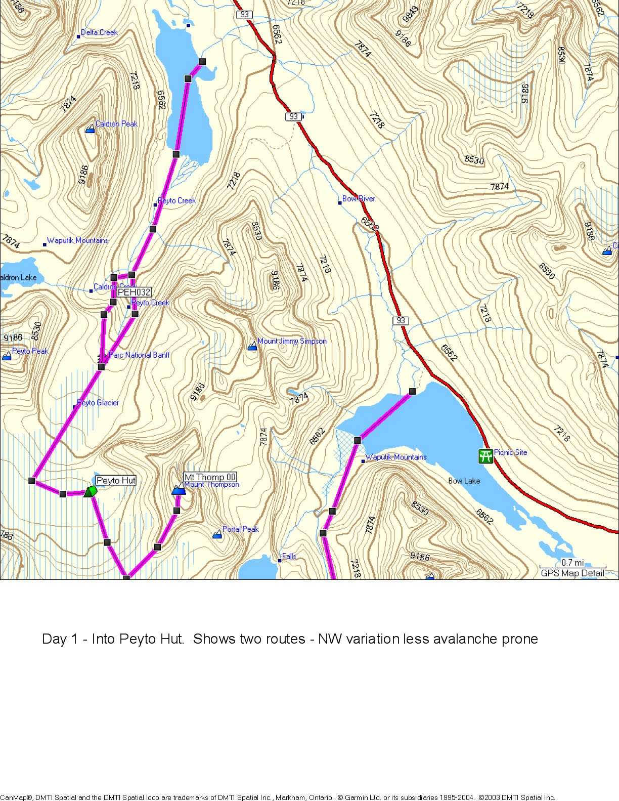
- Day 1 -
routes into Peyto Hut - two routes, Moraine (NW) variation safer in
avalanche conditions
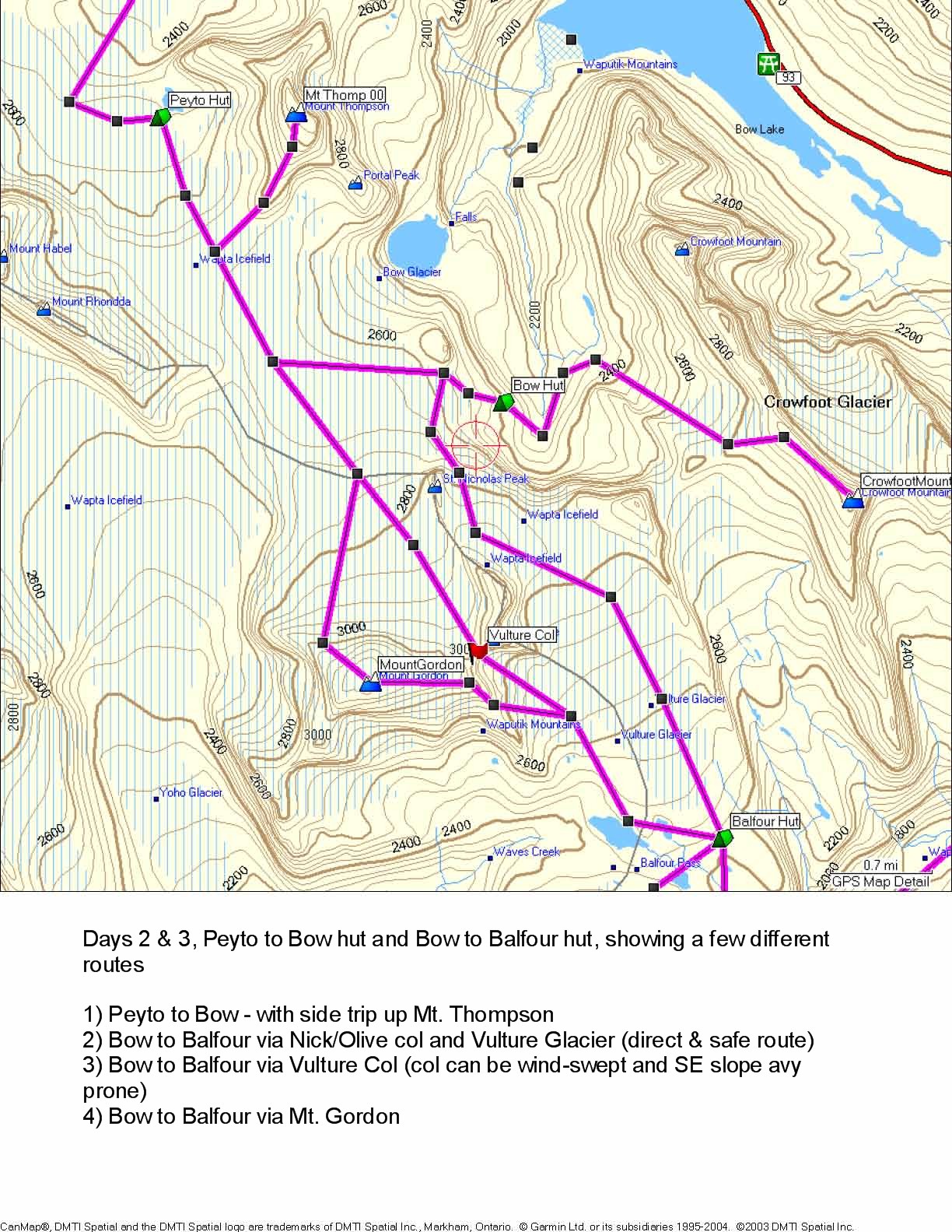
- Days 2-3
- routes from
Peyto to Bow hut and Bow to Balfour hut. Plus:
- Possible side-route to
Mt Thompson on Peyto - Bow trip
- Alternate routes from Bow to Balfour (e.g.
over Mt Gordon or Vulture Col)
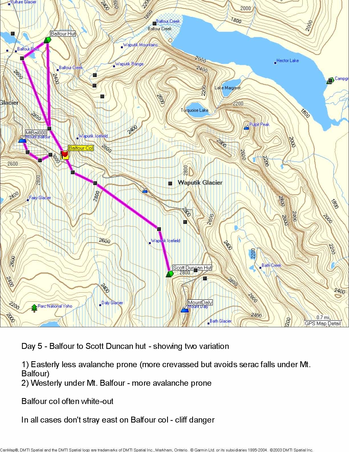
- Day 5
- route from Balfour to Scott Duncan hut, over the Balfour col
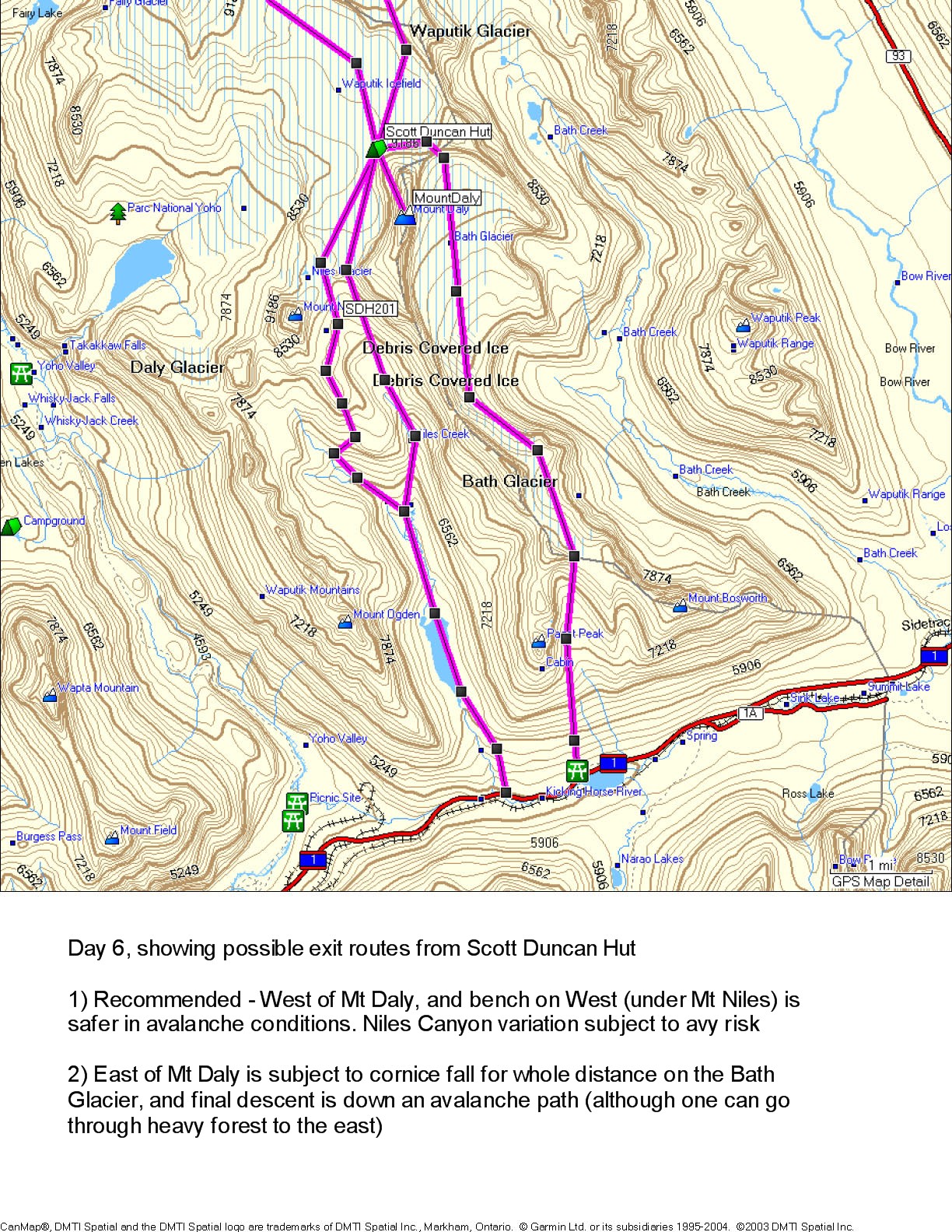
- Day 6
- exit routes from Scott Duncan hut
- Printed map called “Touring the Wapta
Icefields” available at
http://www.canrockbooks.com/si/010165.html
- TSC has some custom maps (probably not as good as above,
but at 1:35,000 vs. 1:50,000) at
http://www.mytopo.com/ca_review.cfm?mytopoid=157522 and
http://www.mytopo.com/ca_review.cfm?mytopoid=157523
Beta
From Robin's friend Nancy:
We did do the Peyto-Bow-Balfour-Duncan and then - truth be told - at
Duncan we turned around and did Duncan-Balfour-Bow-Peyto
again. We heard the ski out was cruddy, cruddy, cruddy and
there was another factor (really good snow? maybe we wanted
to do more turns...I honestly can not remember)
And we went over the Balfour Col. There was one big open
crevasse and avalanche debris on the other side of the crevasse that we
ended up walking very, very close too so I remember that being a
sketchy bit. But others had gone up before us including a
ranger from Colorado and we followed their lead. In March
there should be nice snow bridges especially with the dumps we are
getting this year. I also remember you can check out the
conditions of the Col from these huge, gorgeous windows in the Balfour
hut. The trickiest bit is therefore good for scoping out
before leaving the hut.
We did hear lots of tales of caution involving route finding at that
point in the trail. Our day had clear skies and it was a
simple navigation. In white out conditions you could be
hooped. The ski down after crossing the Balfour Col is simple
but does involve delicate navigation and I remember me and Hans
discussing how people would get themselves in trouble in less than
ideal conditions at that point. You have to traverse across
the back at a specific point or risk going steeply down.
So if it's a white out prepare for an extra day at Balfour.
The rest of the route finding allows for far more error without serious
ramifications from what I remember.
Truth be told the Duncan hut was a little tin can and if you got
beautiful ski days in until that point you could turn around at the
Balfour and still pat each other on the back thinking you had the
greatest time ever. It's gorgeous country. The
Peyto hut is the mountain hut against which all others should be judged
(a couple were getting married there a few days after we left...there
buddies were skiing in the wine!) and you will get good turns in at
Peyto.
This is going on some rusty year old memories but I hope that helps and
you are going to love it!
Nancy
Report from Mark Klassen,
Mountain Guide, Feb 2008
Our group and a Scottish crew tag-teamed across the Wapta Feb 15-18,
starting at Bow and finishing at Sherbrooke.
Conditions on the icefield seem pretty normal for this time of year. Of
note however was that I probed only 250 cm of fairly low density snow
on the toe of the glacier leading to Balfour hi col. That said,
coverage on the route to the col was more filled in than I had ever
seen it, with few signs of crevasses. I didn't probe higher on the
route because I was scurrying away from the seracs, but it was smooth
sailing quite close to the rock nunatak pretty much all the way. The
upper slopes of Balfour were scoured by the recent wind event, with few
cornices above the ascent route.
On Feb 17 we saw a recent size 2 avalanche below a cornice on a south
aspect of Mt Gordon, probably as a result of strong north winds on
Saturday. We also saw plenty of fresh debris below cornices on east
aspects in the Sherbrooke valley today, Feb 18. Lastly, we saw a large
avalanche on a south aspect below a cliff band in the Dolomite Peak
area on the drive back to Bow today. Solar radiation was strong on
south aspects today.
We were fairly conservative in our terrain selection this trip due to
recent avalanche activity. We used the upper bench start to Balfour hi
col (starting at the north end of the moraines) and dropped to the
lower bench half way, to avoid the steep slopes on the direct approach
through the moraines. Traversing below Niles today we dropped down to
about 8100 ft from the Niles-Daly col, this is just above the first
steep slopes on the classic exit. Then we skinned up a short, moderate
moraine slope to regain the Schiesser-Lomas exit. This avoided most of
the exposure from the upper slopes and cornices of Niles that you are
subject to if you take a high traverse from the N/D col.
We had localized whumpfing in the moraines below Niles today, but
nothing up on the icefield and in the trees in Sherbrooke the snow felt
quite supportive, although I'm sure we have a few layers of concern in
that terrain as well.
Report via Steve Bourne (Mar 2008)
Lisa (the ACMG guide) lived and worked in Canmore for 10 years and has
done the wapta many, many times. She suggests that we ought
to have some method of communication, but, more importantly, that we
may want to consider changing our route for day one and entering from
Bow lake instead and going to Balfour hut on day one and if we want
either to just ski Mt Rhonda (as a day trip and back to Bow) or out to
Peyto on day 2. She says the hike in to Peyto across the
peyto lake is super technical at the split before the glacier, then the
glacier traverse is heavily crevassed and that he approach route to the
hut is much wider away than marked on the map and is one of the most
technical aspects of the whole trip.
She says this is extremely ambitious (c.12km) for day 1 with fully
loaded packs and a late start (likely 11 or 12).
She says real chance we will not make hut before dark and very
difficult route that is not frequently traveled by groups.
She says although the route is beautiful, we can get the feeling for it
via a day trip (day 2) to Rhonda. I will, out of an abundance
of caution, make an inquiry as to whether there would be room to stay
at Balfour on Friday, in case we decide to do it this way.
Second report via Steve Bourne (Mar 2008)
Just got off the phone with the president of the Rocky mountain
(canmore) section of the ACC. ... He has been on
the wapta three times this winter and is going this week
again. He says its all good and stable, and the peyto route
is long for a day with all our gear, but very manageable as long as we
choose the high route through the canyon at the entrance to Peyto
glacier. He says going through the canyon with all our gear
is way too exposed - and was strong about that. he says he
hasnt roped in all year, except in the usual balfour col
area. Says we should do the hike to Peyto in about 5 hours,
give or take.
Online Trip
Reports
Guiding outfit’s Yamnuska description, gear list, etc.:
http://www.yamnuska.com/waptatraverse.shtml
SMS 2005 trip report w/ maps:
http://angeles.sierraclub.org/skimt/trips/wapta05/wapta05.htm
Trip report with pics from 2004, done with Yamnuska:
http://www.dskendall.com/skiing_wapta.html
Good trip report from experienced (unguided) group (starts on p. 5)
http://alpineclub-edm.org/breeze/200302.pdf
Nice trip report on classic traverse.
http://gritstone.ca/personal/igraham/wapta/day1.html
Accidendt Report from Balfour Col incident:
http://alpineclub-edm.org/accidents/accident.asp?id=915 – skier fall
off cliff at Balfour High Col
Report of Wapta traverse (not as good as above):
http://sverdina.com/wapta/wapta1.htm
http://dowclimbing.com/WaptaIcefields.html
http://teleplanker.blogspot.com/2007/05/wapta-icefield.html - shorter
route, and got turned back
http://www.outdoors.org/publications/outdoors/2005/toolsgps.cfm
(Michael Lanza from AMC)
http://bivouac.com/TripPg.asp?TripId=5498 - must be paid member, and
not our route, but does have java map and waypoints
Crevasse Rescue and
Glacier Travel Resources
-ACMG online information:
http://www.acmgguides.com/html/tipstech/mountaineering_contents.asp
-Glacier Travel & Crevasse Rescue by Andy Selters- ROBIN good
but not great, more mountaineering focused
-Videos online: search YouTube for “ACMG crevasse rescue”, should bring
up several videos by guide Cliff Umpleby
Gear
Go as light as safely possible. It is a hut-to-hut trip, but we’ll
still be carrying a decent amount of weight due to food, sleeping bags,
crevasse rescue gear, etc. Extraneous weight slows the group down,
increases energy expended and chance of injury, and makes skiing less
enjoyable. I’ve tried to keep the gear list consistent with what is
typically listed for guided groups.
Hardware
- Skis
- Boots
- Poles
- Climbing skins
- Avalanche beacon w/ fresh batteries
- Probe
- Shovel
- Lightweight ice axe ROBIN, JOHN thinking about at least one
or two for the group or OPTIONAL if anyone has mountaineering
aspirations
- Crampons OPTIONAL thinking about a minimum one or two pairs
for the group, ROBIN I’ll be bringing a light pair
- Ski crampons OPTIONAL, don’t bother if you’re bringing reg
crampons
- Ropes- 2 x 40 m, 8.5 mm JOHN
- Slings- 1 double-length
- Prussiks, 2, Texas prussik setup
- Carabiners, probably 2 locking and 2 non-locking
- Pulley OPTIONAL
- Harness- adjustable leg loops are preferable
Clothing/Personal-
be prepared for below freezing temps during the day and wind
- Liner socks OPTIONAL
- Regular socks, 2 pairs
- Booties or hut shoes OPTIONAL
- Fleece pants or thick long underwear
- Shell jacket, waterproof OPTIONAL insulated jacket might be
sufficient
- Shell pants, waterproof or soft shell
- Insulated jacket, down or synth
- Light jacket- fleece, driclime, softshell, etc.
- Base layer shirt, maybe 2
- Winter hat
- Sun hat
- Balaclava or neck warmer
- Liner or light gloves
- Gloves or mitts
- Sunscreen and lip balm
- Sunglasses
- Goggles
- Toiletries and personal first aid supplies (moleskin,
ibuprofen, etc.)
- Earplugs, or cyanide to put in Mark’s tea
- Sleeping bag- some huts are unheated, so at least 3-season
recommended, can go light by wearing extra clothing in the bag
Other
- Water bottles and/or insulated Camelback, at least 2 litres
capacity
- Emergency kit- mylar bag, chemical heat packs, lighter ROBIN
- Thermos OPTIONAL
- Headlamp / batteries
- Camera / batteries OPTIONAL
- Compass- at least 2 in the group
- GPS- 2, TOM, ROBIN
- Maps- at least 1, STEVE
- Altimeter watch- a couple of people have them
- Group First Aid kit- STEVE/ROBIN
- Leatherman/multi-tool ROBIN
- Repair kit- sections of alum angles, locking wire, pipe
clamps cable, epoxy, skin wax, duct tape, etc. ROBIN
- Satellite phone- will plan on picking up one from the ACC
in Canmore
- Radios, light Motorola type MARK
- Snow study kit and snow saw ROBIN
- Avaluator ROBIN, TOM
- Stove- TOM wants to have one along- group decision
TBD/OPTIONAL
- Locks, 2 ROBIN for storage lockers in Lake Louise
Not Required
- sleeping pads, pots, utensils, mugs, helmets, bivy bags, pickets, ice
screws, cell phones (no reception)
- note from TSC - reconsider bivy bags with late start Fri?
Food and Menu Planning
- DINNER - Ordered by TSC
- Soup for each night (we can buy in Calgary but maybe
easier to buy before-hand)
- First night: tuna and cous-cous (buy in Calgary -
somewhat heavier)
- Nights 2-6: freeze-dried dinners.
- Order from the internet - e.g. rei.com or
wildernessdining.com - each dinner comes as 4-serving packet
and I suggest two packets each dinner (8 servings)
- Here's what I suggest - I chose these for high calorie
and high grams from fat.The price is for two packets. (Some
other choices are Pasta Primervera, 300cal; Lasagna 290cal)
| www.wildernessdining.com |
|
|
|
|
|
|
| Product |
No. |
Total |
Servings |
Cal |
g Fat |
Producer |
| Rice & Chicken |
2 |
20.90 |
8 |
410 |
14 |
Mountain
House |
| Wild Tyme Turkey |
2 |
23.90 |
8 |
370 |
11 |
Alipine
Aire |
| Chicken Rotelle |
2 |
24.70 |
8 |
360 |
10 |
AlpineAire |
| Beef Stroganoff |
1 |
10.95 |
4 |
360 |
8 |
Natural
High |
| Pasta Primavera |
1 |
10.45 |
4 |
300 |
9 |
Mountain
House |
| Leonardo da Fettuccine |
2 |
17.90 |
8 |
330 |
19 |
Alpine
Aire |
|
|
|
|
|
|
|
- BREAKFAST - Made and ordered by TSC
- Muesli with oatmeal, nuts, cranberries,
dried mild, protein powder
- Three packs of dried egg mix (scrambled eggs) - protein
and a little variety for 3 mornings
- Hot chocolate - 24 packets
- LUNCH - to be bought in Calgary
- cheese, peanut butter for, maybe some tuna for the first
couple days, salami,
- tortillas
Avalanche Information
- Article on weak
snowpack of 2007-8 season in Rockies/BC - Must Read!!!
- Avaluator
- Companion Rescue Card (print out
and laminate)
- Canadian Avalanche Association online
avy knowledge
refresher, FREE, turn your computer volume down:
- Current Avalanche Reports
- Archived avalanche reports - general link to CAC web-site
and specific dates I've archived
- 11-mar-2008
. Main concern is Feb 27 surface hoar. "This layer is anywhere from
10-70 cm down and even ... right up to the mountain tops in the alpine.
... The best bet right now is to assume that it is there on any given
piece of terrain. ... We recieved a report of a skier remote on Mt.
Gordon on the Wapta Icefields near the ridge crest at 2900m. ... Its
out there! Mind your P's and Q's."
- 3-mar--2008
. Some slabs on NE aspects burying last week's surface hoar.
Otherwise, new snow bonding
to old and adding to midpack strength. Still need more snow and warm
weather before widespread bridging of basal facets.
- 24-feb-2008
. Very good synopsis of current snow-pack issues. "spring
like weather has helped stabilize weaknesses in the upper
snowpack, through steady settlement." But deeper, basal
facets
not healing, so "little improvement to the overall snow stability is
actually occurring. What we are seeing is a greater
potential for
avalanches that do start, to propagate greater distances."
- 14-feb-2008.
- General link for CAC archived
reports
For More Details (Banff, Yoho and Kootenay National Parks)
Warden Office: (403) 762-1470
Emergency: 403 762 4506
24 Hours Recorded Message: 1-800-667-1105
Route Ratings from CAC
On-Line Avaluator
- Peyto Glacier Approach:
Complex,
- Mt. Rhondda S from Huts: Challenging, Mt. Rhondda N: Complex
- Peyto Hut to Bow Hut: Challenging
- Bow Hut to Balfour Hut via Nic / Olive col: Challenging,
- Mt Gordon: Challenging, Mt. Olive: Challenging
- Mt. Balfour: Complex, Diablaret Glacier: Challending
- Avaluator: Balfour to Scott Duncan Huts: Complex
Travel & Contact Information
See this page -
password protected
Waypoints & Waypoint Management (igrnore this)
WAYPOINT MANAGEMENT: http://www.easygps.com/default.asp
WAYPOINTS:
The UTM for the Balfour high col is NH 384 120 on an older NAD 27 map.
For the newer NAD 83 maps it would be NH 383 123. The Murray Toft
composite map, revised third edition, does not have a clear indication
marked on it, but it appears to be NAD 27. … we advise groups to trend
towards skiers right in poor visibility rather than trending skiers
left. This may result in an increased likelihood of encountering
crevasses, but a reduced likelihood of falling over a cliff.
(http://alpineclub-edm.org/accidents/accident.asp?id=915)
(from http://www.alpineclubofcanada.ca/facility/bow.html)
• Peter and Catharine Whyte (Peyto) Hut
GPS Coordinates: 51°39' 48"-116°32' 42" 11U 531470 5723692 (I think
NAD83)
• Bow Hut GPS Coordinates: 51°38'
06"-116°29' 24" NAD27 (I think should be NAD83) 11U 535296
5720566
• R.J. Ritchie (Balfour) Hut GPS
Coordinates: 51°35' 30"-116°27' 18" NAD83 11U 537754 5715765
• Scott Duncan Hut GPS Coordinates:
51°31' 42"-116°24' 06" NAD83 11U 541506 5708750
In Setup->Units set Position Format to UTM/UPS and Map Datum to
NAD27 (Canada). Scott’s Bow Hut Grid Reference of 355203 is simply a
3-digit representation of the Easting (355) and a 3-digit
representation of the Northing (203) lumped together to make a single
number. A key piece of information that I lacked, however, is that the
1:50,000 National Topographical Series maps, similar to Murray Toft’s
Touring the Wapta Icefields, assumes an Easting ‘prefix’ of 05 and a
Northing ‘prefix’ of 57. Knowing this, the Easting then becomes
0535500. I zero-filled the remaining two spaces to complete the 7-digit
number the GPS requires for the Easting (the Grid Reference is
sufficiently accurate anyway). Similarly, the Northing then becomes
5720300. Of course, one could just read the Grid References directly
off of the map, which I did for key features such as Olive – Nic. Col,
Balfour High Col etc